
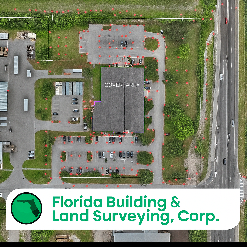
Florida Building & Land Surveying, recently completed a detailed Drone Survey in the scenic coastal community of Apollo Beach, Florida. This project combined traditional land surveying methods with cutting-edge drone technology, allowing our team to deliver unmatched accuracy and efficiency.
Exploring Apollo Beach, Florida
Nestled along the eastern shore of Tampa Bay in Hillsborough County, Apollo Beach is one of Florida’s most scenic waterfront communities. Known for its relaxed coastal charm, boating lifestyle, and family-friendly atmosphere, this area continues to grow as both a residential and commercial destination.
Visitors and locals alike enjoy the Apollo Beach Nature Preserve, a stunning spot for walking trails, photography, and sunset views over Tampa Bay. Another major attraction is the Manatee Viewing Center, where people can observe Florida’s gentle sea cows in their natural environment. With its marinas, waterfront dining, and convenient access to Tampa, Riverview, and Brandon, Apollo Beach offers a perfect balance of development and natural beauty—making it a prime area for new construction, land development, and investment.
Our Process: Combining Tradition and Technology
At Florida Building & Land Surveying, Corp., we’ve mastered the art of blending traditional surveying methods with advanced drone technology to create highly accurate and detailed land surveys. This dual approach not only saves time but also enhances safety and precision—especially on large commercial properties like the one surveyed in Apollo Beach.
Here’s how our process works:
-
Ground Control Setup
Our field crews establish precise control points using GNSS receivers and total stations. These serve as the foundation for all measurements, ensuring every coordinate aligns with true Florida State Plane system accuracy. -
Drone Data Collection
Next, we deploy RTK (Real-Time Kinematic) drones to capture high-resolution aerial imagery and elevation data. The RTK system allows for centimeter-level precision, mapping every visible feature of the site, from pavement edges to roof outlines and drainage structures. -
Photogrammetry & Data Processing
The collected imagery is processed through advanced photogrammetry software to generate orthomosaic maps, digital terrain models, and 3D surface data. These datasets are merged with ground survey points to create a unified, georeferenced map of the property. -
Quality Control & Certification
Every detail is reviewed and certified by Rick Morales, P.S.M., ensuring compliance with Florida state surveying standards and ALTA/NSPS requirements. The result is a professional-grade deliverable ready for engineers, title companies, and developers.
This integrated workflow allows us to deliver accurate, detailed surveys faster than traditional methods alone—without compromising the professional integrity that defines our work.
Why Clients Choose Florida Building & Land Surveying, Corp.
Our clients count on us for accuracy, reliability, and responsiveness. By utilizing UAS (Unmanned Aerial Systems) alongside traditional surveying tools, we provide data-rich deliverables ideal for engineering design, site planning, boundary certification, and title insurance requirements.
Whether you’re developing a commercial property, refinancing an existing site, or purchasing new land, our team ensures that your survey is handled with precision and professionalism from start to finish.
Contact Us
When it comes to ALTA surveys, topographic mapping, boundary retracements, and elevation certificates across Florida, trust the experienced professionals at Florida Building & Land Surveying, Corp.
📍 Serving all of Florida — including Apollo Beach, Tampa, Riverview, Brandon, and surrounding areas.